In the impressive and interminable valleys of the southern slope of the Himalayan range, the road is regularly cut by landslides or enormous avalanches, particularly frequent in spring. We spent four days to Zhangmu, a Tibetan village close to the Nepalese border, to wait until the road is released
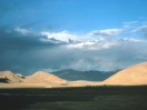
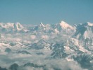
After having crossed the Himalayan range, we discover, in north, the high Tibetan plateaus. Although the color of these highlands is generally monotonous, the combined play of the clouds, the wind, sand and the sun, in an atmosphere of dry and rarefied air, creates a surprising light and colours. We are under the charm of this immense landscape and discover the real dimensions of this territory.

Langgolo, end of the motor-road. The serious things start: 41 barrels, 18 paperboards, 36 packages of gas, 10 marine bags, 9 cans of kerosene, 6 personal tents, 1 kitchen tent, 1 mess tent, 15 bags of food for the base camp, i.e. a load of 2.5 tons… then, one starts with what?
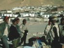
Langgolo, small village of 700 inhabitants which practically lives in autarky, at immutable pace since centuries. One cultivates there barley and a little lenses. The villagers accomodate us in an interested way: it is the third time in their history they see rich foreigners who cross thevillage for climbing their mountains.

To load our barrels and our paperboards on the yaks requires a great skill and a considerable know-how. The drivers must also show perseverance to repeat the operation in way, when the yaks lose their docility and send their loads to several meters.

A yak transports, according to the season, between 40 and 60 kg. It is one of the only richnesses which the Tibetans have. Its skin and its wool are used to manufacture clothes, its dungs to heat the houses, whereas its milk and its meat are used as food. Living at an altitude ranging between 3500 and more than 5000 meters, the yak is economic and nourishes with almost anything, being satisfied sometimes with lichens.

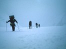
It is 21 km and a hard day of walk to reach the top of the valley and to establish the base camp there. The pace of the 27 yaks is excellent. Their nine drivers remotely direct them by whistles, cries or in throwing them small stones.
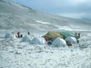
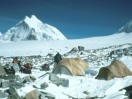
The base camp, at 5300 m. It will shelter the ten mountaineers, their cook and his young Tibetan assistant during 5 weeks. The cold often, the snow sometimes and the wind all the time, make this place an austere and difficult place to live. It will be however the most comfortable and most luxurious camp for the whole period of the expedition.

It is necessary to cross the lake LAMA to reach camp 1. The ice which covers it in spring makes it possible to traverse it over all its full length of 7 km. During the 1987 expedition, held in autumn, the mountaineers found water and some plates of drift ice and they had thus to follow its long bank.

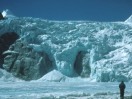
At the end of the lake, an impressive, 400 m high fall of seracs closes the valley. We knew that the Sino-Japanese expedition of 1987 had found a passage towards the higher glacier, at the far right hand end of the fall. Quite naturally, we take the same route which, with the comings and goings, becomes a familiar course.
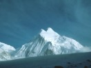
Camp 1, 5750 m, offers a splendid sight on the northern slope of Labuche Kang II. By where will we climb this mountain? By the Western col, very exposed by the winds and of which we don't know anything? By the North ridge, which looks very beautiful but which seems rather long ? Or then by the East col, which we had located on the photographs at the time of our preparation?

Leaving camp 2, a team makes its track towards the East ridge. The route to the summit first crosses a problematic bergschrund, then avoids a zone exposed to threatening seracs, for finally using a rather secure line of ascent which leads directly to the main summit.

With the interruptions due to the bad weather, it takes one week for the openers to equip the mountain with ice pitons and fixed ropes on 700 m. Below, the other mountaineers bring this material as well as gas and food necessary to live in the high altitude camps. It is team work in which each one needs the other.

The ridge becomes steeper. Fixed at solid anchors, the rope makes it possible to the mountaineers to progress on a slope which as a whole is about 55 degrees. It offers safety and an effective help to progress upwards by means of jumars.


- Here base camp, we receive you.
- Above us, there is nothing but the sky.
- Super… congratulation!
The arrival at the top is one privileged moment where the joy erases the difficulties, the sufferings, the doubts, and where each one is delighted for the other.